Severe Weather Expected Through The Afternoon Into The Evening Across The Area
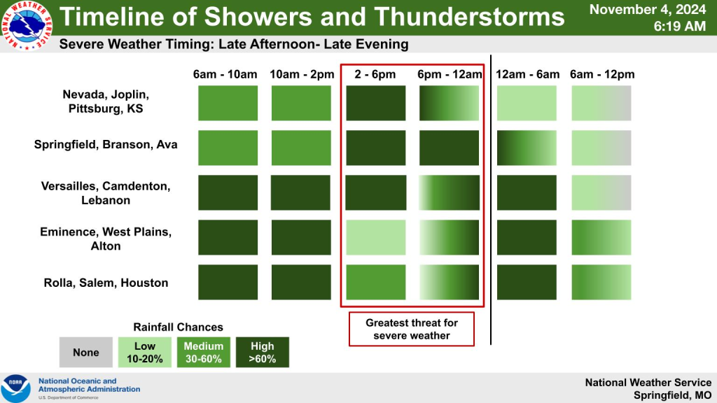
Some severe weather is expected this afternoon into the overnight hours across the Lake Region.
According to the National Weather Service, portions of the Lake Area including Camden, Laclede, Dallas, Hickory and some of Miller and Morgan Counties all are falling in the Enhanced Risk area, while the rest of the region is in a slight risk category.
Weather officials are anticipating isolated hail damaging winds up to 80 miles an hour and tornadoes to be the main threats with this system.

More details from the NWS:
This Hazardous Weather Outlook is for portions of the Missouri
Ozarks and extreme southeast Kansas.
.DAY ONE…Today and Tonight.
Weather hazards expected…
Elevated excessive rainfall risk.
Elevated lightning risk.
Enhanced thunderstorm wind damage risk.
Enhanced tornado risk.
Slight hail risk.
DISCUSSION…
Showers and thunderstorms will continue to push northeast from
northwest Arkansas and northeast Oklahoma through the early
morning hours. Storms are unlikely to be severe, but gusty winds
could be possible with strong thunderstorms this morning. Heavy
rainfall rates could lead to flooding where storms develop and sit
over the same areas, especially within the eastern Ozarks. Areas
southeast of Interstate 44 have the highest chances of excessive
rainfall, with an additional 2 to 5 inches of rain expected to
fall by Tuesday morning. This heavy rainfall is the basis for a
Flood Watch for portions of southeast Kansas and southern
Missouri, which remains in effect until 6 AM on Tuesday.
This afternoon brings another round of heavy rain and severe
storm chances through the area. A line of storms will develop
along a cold front, and embedded supercell storms could form
ahead of the cold front before merging into the line. All storms
will bring the risk of damaging winds up to 60 to 80 mph, and
there is a chance of embedded nocturnal tornadoes within the line
if instability increases behind morning convection. Hail up to the
size of quarters will also be possible. Storms will persist into
Tuesday morning.
.DAYS TWO THROUGH SEVEN…Tuesday through Sunday.
After storms and heavy rainfall move east on Tuesday, conditions
will be quiet before rain chances between 30 and 50 percent return
on Friday.
.SPOTTER INFORMATION STATEMENT…
Spotter activation may be needed today and tonight across the
southern Missouri Ozarks.


