Red Flag, High Wind Warnings In Affect Ahead Of Severe Weather Outbreak
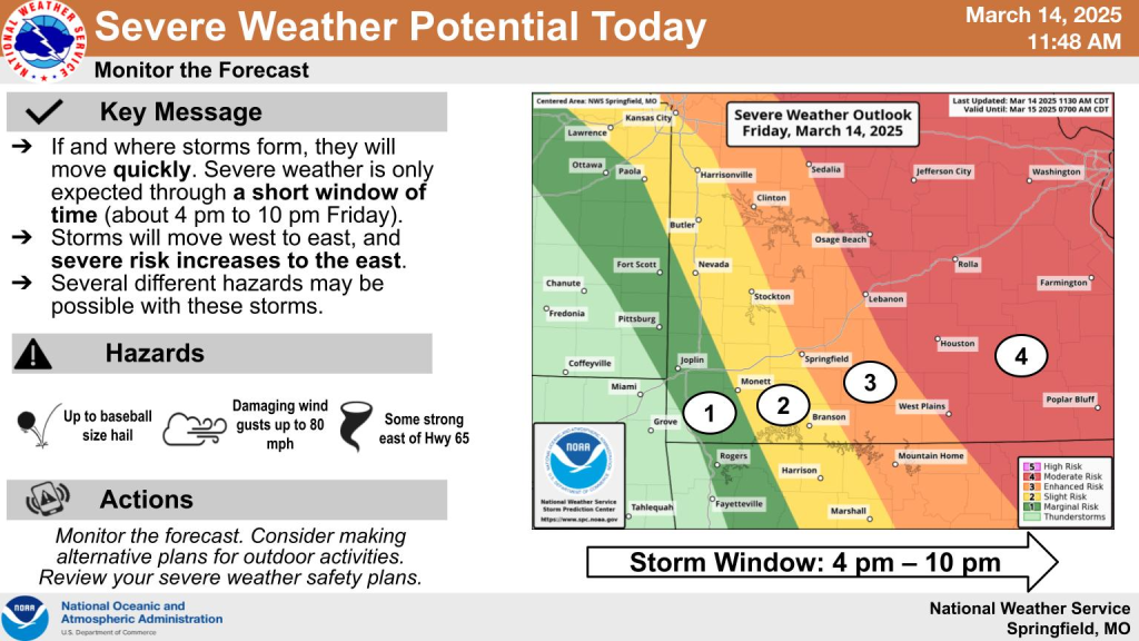 A number of weather warnings are affecting the majority of the lake region ahead of tonight’s severe weather outbreak.
Before the storms hit the region, lake residents are already under a “high wind warning” as well as a “red flag warning” due to the current conditions.
Red Flag warnings mean burning is not recommended due to the extremely dry conditions, high winds and moisture in the air…which could lead to a small fire turning into a raging wildfire.
Fire officials are requesting residents call ahead of time to discuss any plans for burning before tonight’s severe weather event, which officials with the National Weather Service believe will begin this afternoon.
Both the Red Flag and High Wind warnings are in effect until Saturday.
For more on the weather and any watches or warnings, make sure to stay tuned to KRMS radio or follow us on social media.
More info:
 .
.
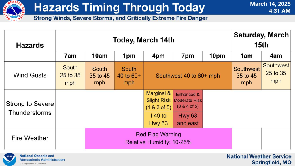
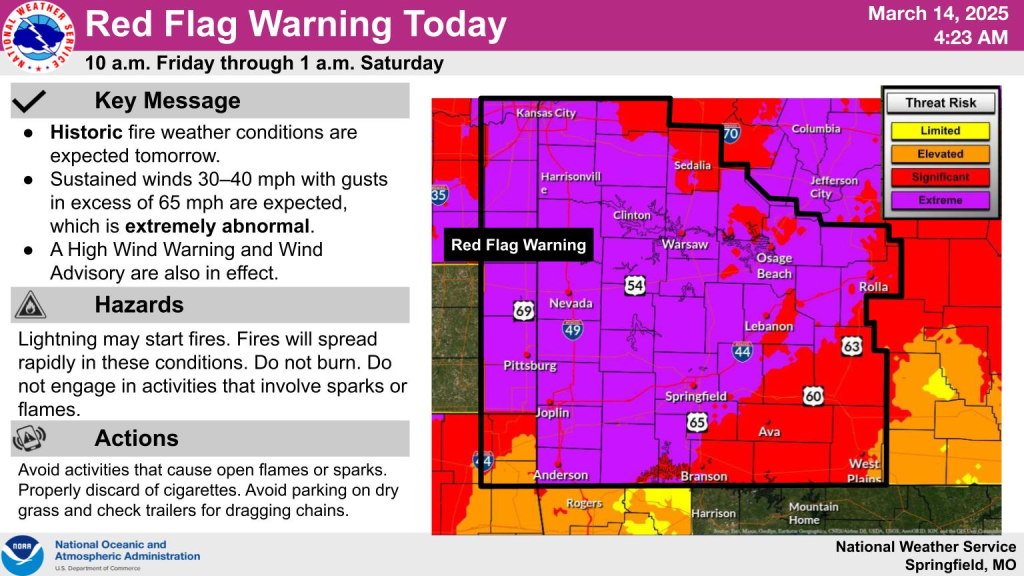
..RED FLAG WARNING REMAINS IN EFFECT FROM 10 AM THIS MORNING TO 1 AM CDT SATURDAY FOR VERY STRONG WINDS AND DRY CONDITIONS FOR PORTIONS OF SOUTHEAST KANSAS AND SOUTHWEST MISSOURI…
* AFFECTED AREA…Benton, Morgan, Miller, Maries, Hickory, Camden, Pulaski, Phelps, Dallas, Laclede*
TIMING…From 10 AM this morning to 1 AM CDT Saturday.
* WINDS…South 30 to 40 mph with gusts of 45 to 65 mph.
* RELATIVE HUMIDITY…As low as 15 to 25 percent.
* TEMPERATURES…Up to 79.
* LIGHTNING…Isolated to scattered thunderstorms are possible, especially east of Highway 65 this afternoon and and evening, but most locations may remain dry. Outdoor burning is strongly discouraged.
PRECAUTIONARY/PREPAREDNESS ACTIONS…
A Red Flag Warning means that critical fire weather conditions are either occurring now, or will shortly. A combination of strong winds, low relative humidity, and warm temperatures can contribute to extreme fire behavior.
-o-
 .
.
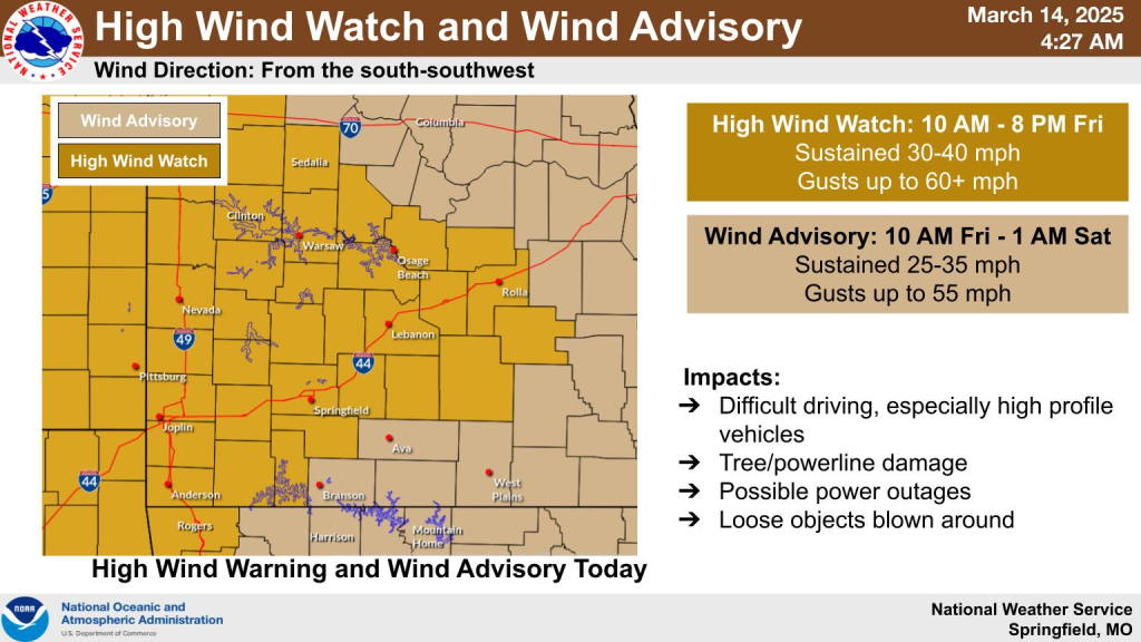
..HIGH WIND WARNING IN EFFECT FROM 10 AM THIS MORNING TO 1 AM CDT SATURDAY…
* WHAT…South winds 25 to 35 mph with gusts up to 60 mph expected.
* WHERE…Portions of central, east central, south central, and southwest Missouri.
* WHEN…From 10 AM this morning to 1 AM CDT Saturday.
* IMPACTS…Damaging winds will blow down trees and power lines. Widespread power outages are expected. Travel will be difficult, especially for high profile vehicles.
PRECAUTIONARY/PREPAREDNESS ACTIONS…
Watch for falling debris and tree limbs. Use caution if you must drive.
****Severe Weather Discussion from Max Velocity:

Reporter John Rogger