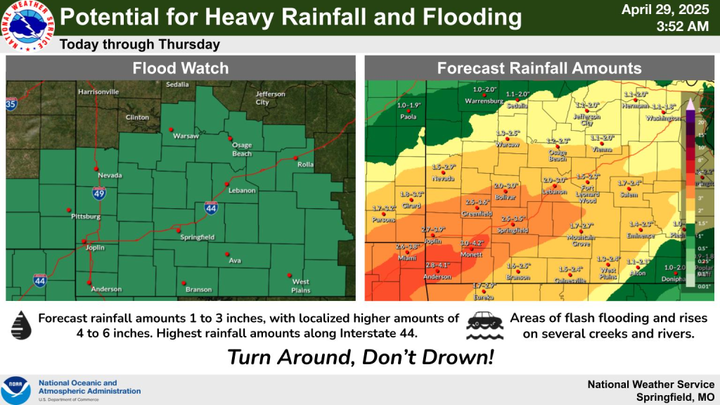
Flood Watch In Effect Until Thursday Across The Lake Region
From the National Weather Service…..Flood Watch in effect in Camden, Miller, Morgan, Benton, Hickory, Laclede, Pulaski, Maries and Dallas Counties….

…FLOOD WATCH REMAINS IN EFFECT FROM 7 AM CDT THIS MORNING THROUGH
THURSDAY MORNING…
* WHAT…Flooding caused by excessive rainfall continues to be
possible.
* WHERE…Portions of southeast Kansas, including the following
areas, Bourbon, Cherokee and Crawford and Missouri, including the
following areas, Barry, Barton, Benton, Camden, Cedar, Christian,
Dade, Dallas, Dent, Douglas, Greene, Hickory, Howell, Jasper,
Laclede, Lawrence, Maries, McDonald, Miller, Morgan, Newton,
Oregon, Ozark, Phelps, Polk, Pulaski, Shannon, St. Clair, Stone,
Taney, Texas, Vernon, Webster and Wright.
* WHEN…From 7 AM CDT this morning through Thursday morning.
* IMPACTS…Excessive runoff may result in flooding of rivers,
creeks, streams, and other low-lying and flood-prone locations.
Low-water crossings may be flooded.
* ADDITIONAL DETAILS…
– Multiple rounds of showers and thunderstorms are expected
today through Thursday morning. Expect widespread amounts of
1 to 3 inches, with localized amounts up to 4 to 6 inches
within areas that see multiple rounds of heavy rain within
thunderstorms.
– http://www.weather.gov/safety/flood
PRECAUTIONARY/PREPAREDNESS ACTIONS…
You should monitor later forecasts and be alert for possible Flood
Warnings. Those living in areas prone to flooding should be prepared
to take action should flooding develop.

Reporter John Rogger